The Ancient Plants That Fueled Early Missoula
by Kallie Moore
Today, Missoula’s North Hills are undulating low mountains between Rattlesnake Valley to the east and Grant Creek Valley to the west. They sit snugly between the larger mountains of the Reservation Divide Range, darkened with evergreens of Lolo National Forest, and the Clark Fork River basin that’s filled with Missoula. They also display city landmarks like the Peace Sign on Waterworks Hill and the Moon-Randolph Homestead, as well as the necessary eyesore of the Missoula Landfill.
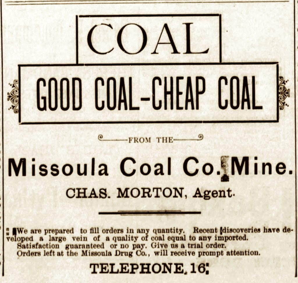
First coal ad in The Missoulian, Dec. 24, 1895
Now if you’ve ever gone to the landfill, you might have noticed that it is located off of Coal Mine Road…but there’s no sign of either coal or a mine. However, this wasn’t the case during the early days of Missoula. Likely starting in the 1870s, Missoulians were removing coal from these hills and in some cases establishing full-scale mining operations.
And not only was there coal to fuel the city, but also a volcanic ash layer that contained fossil leaves—to fuel the research of a fledgling University of Montana. These leaf fossils represent some of the only fossils ever discovered in the Missoula Valley. So where did the fossils and coal come from? How old are they? And what can they tell us about a Missoula from the prehistoric past?
Let’s go back to the Cretaceous Period, about 80 million years ago. Around this time the oceanic Farallon Plate began sliding under the western edge of the continental North American plate. As the plates scraped together they kicked off a mountain-building event known as the Laramide Orogeny, creating the modern Rocky Mountains.
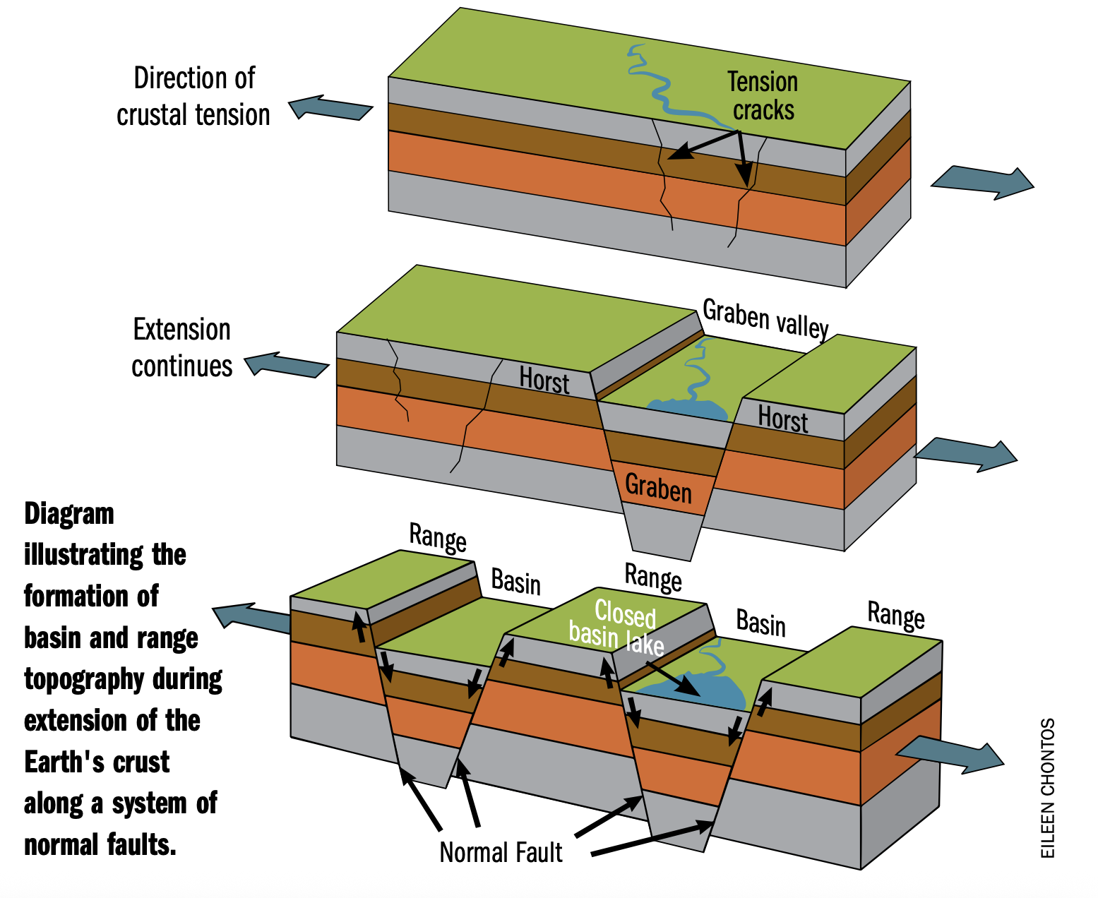 Then, around 50 million years ago during the Eocene Epoch, the plates relaxed, and instead of smashing into each other, they started pulling apart in a process called crustal extension. This can cause the crust to weaken and sink down along faults to form basins known as grabens. In fact, Missoula Valley occupies the corner of a graben that is bounded by the Mount Sentinel Fault to the east and the Clark Fork – Ninemile Fault to the north. These two faults are part of the reason why both Mount Sentinel and Mount Jumbo have such sheer faces.
And not only was the crust weaker, it was also thinner in some places. This thin crust ignited widespread volcanic activity across western Montana and eastern Idaho. There were regional lava flows and an immense amount of ash was spewed into the air for around 10 million years.
At the same time, erosion rapidly expanded valleys and defined basins. Eventually, braided meandering streams and rivers developed. However, these fluvial systems were constantly being clogged by all that ash. This caused the water to abandon channels and overflow banks. In those areas with standing water, a marshy environment could take hold. And sometimes there was enough water to fill a basin, producing a lake.
The volcanic ash that fell or was washed into the lake slowly settled to the bottom. Ultimately this lake bottom would lithify, becoming one of the rock layers we see today in the North Hills. These volcanic ash beds are sometimes referred to as pumicite or tephra. The color ranges from almost pure white to gray and yellow to orange from being stained with iron. And the great thing about volcanic ash is that it’s made of microscopic glass (silica) that can be radiometrically dated. Researchers use decay rates of radioactive isotopes of potassium and argon to estimate when the ash formed. Back in 1995, the North Hills ash was found to have a fission-track date of 39 million years—give or take a million or so. This date overlaps with the end of the Challis magmatism in central Idaho, a potential source of the ash.
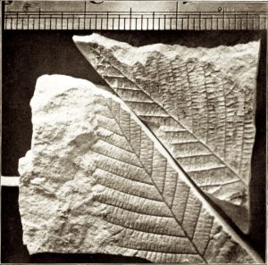
Leaves from volcanic ash found in Missoula. From Rowe’s 1903 publication – first mention of fossils.
Not only has the North Hills ash given us an age, but it also contains basically the only fossils found in Missoula. Leaves and fruits of plants living in the area during the late middle Eocene also made their way into the lake, sank to the bottom, were buried by ash and other sediments, then preserved as fossils. These plant fossils were first mentioned in 1903 by Dr. Jesse Perry Rowe, Professor of Physics and Geology at the University of Montana (UM). A collection of these leaf fossils was also made the same year by Earl Douglass, UM’s first master’s degree recipient. These specimens were used later, in 1920, to more formally describe the deposit. Today, various institutions, including the Smithsonian and the Carnegie Museum of Natural History, house collections of fossils from the North Hills.
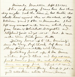
“…dug out some fossil leaves from the ash beds there. Some are very fine.” Douglass field notes, 1903.
The fossil leaves mostly represent deciduous trees that we could find in Missoula today, like alder, cottonwood, birch, oak, and maple. But others aren’t found in Montana today and, in one case, no longer even grow on this continent. For example, today, Taxodium, the bald cypress, grows natively only in the southern U.S. And Metasequoia, or the dawn redwood, was restricted to China for at least the last 2.6 million years, and thought to be extinct until Chinese botanists discovered a living specimen in 1944. Scientists at Harvard University re-introduced the dawn redwood to North America in 1948. Both species are present in the North Hills ash bed.
So the plant fossils can tell us something about the climate of Missoula around 39 million years ago. To support a thriving population of trees like the dawn redwood and bald cypress, the climate would need to have been a little warmer and slightly wetter. This is also supported by evidence of a global warming event known as the Middle Eocene Climatic Optimum (MECO) that happened around the same time. It is estimated that temperatures in North America spiked by 9 degrees Celsius (16.2 degrees Fahrenheit) over the course of roughly 500,000 years! The cause of the MECO has been attributed to an increase in atmospheric CO2 and deep-ocean acidification, possibly due to changes in weathering (which usually lowers CO2) or volcanism (which usually raises CO2).
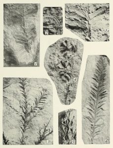
Jennings (1920) Plate 2: 1 – Sequoia; 2 – Sabina; 3, 4 – Sequoia; 5 – Thjopsis; 6 – Sequoia
In addition, increased precipitation during the MECO, plus the ash-blocking drainages, created pockets of swamps—perfect conditions for the formation of coal. Now, the coal that comes to mind is probably “hard coal,” aka anthracite. The largest anthracite deposits in the United States are in northeastern Pennsylvania and are around 300 million years old, from the Carboniferous Period. This is the most sought-after (and rarest) form of coal because it has the highest carbon content, the fewest impurities, and produces the most energy. But there are several different types, or “ranks,” of coal.

Fossilized Betula (birch) leaves from the University of Montana Paleontology Center collection. Scale bar is 5 cm.
Coal starts out as dead plants. Partially decomposed organic matter builds up in a wetland to form peat. Peat has many uses and it can be harvested, dried, and burned as fuel. This practice goes back to the Romans and continues today in countries like Ireland. If the peat is buried, a process called coalification can start. The weight of the overlying sediments squeezes out most of the water and compacts the peat. As the material is buried deeper, it’s exposed to more pressure and higher temperatures. And with time, usually millions of years, chemical and physical changes occur, transforming the peat first to lignite, then to sub-bituminous coal, bituminous coal, and, finally, anthracite coal. And, fun fact—if this process continues, anthracite turns into graphite, most commonly used as pencil “lead.”
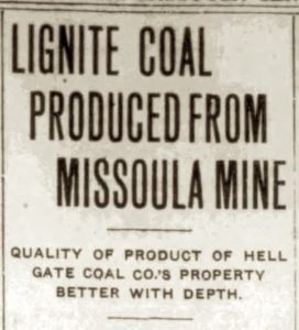
So what form of coal is found in Missoula? The North Hills contain around three major seams of a high-grade lignite coal ranging from three to eight feet thick and layered between ash, clay, conglomerate, siltstone, and sandstone. This lignite is dull brown to black and dense, but brittle. When exposed at the surface the coal tends to “blossom,” turning a reddish-brown color resembling rotten wood mixed with soil. One drawback (especially in the opinion of the railroad) was that, after about three weeks of exposure, the lignite would start to crumble, or slack, making it impossible to transport and limiting its economic potential. Also, the North Hill’s lignite generated a lot of ash when burned. But even though it wasn’t high-quality enough to be a real money-maker, it was good enough for producing steam and using as a domestic fuel.
The Missoula Sentinel, Mar. 21, 1911
The first published analysis of the lignite was done in 1886. The report was based on samples that were collected from “Hell Gate, Missoula River” three years prior. By 1889, Missoula men founded the first of several mining companies that would form over the years. Throughout the early 1890s, various parties leased the coal land, and by May 1895 a 75-foot tunnel had been dug along the coal vein. They extracted a chunk of coal that weighed 250 pounds, and it was estimated that one man could mine two-and-a-half tons of coal per day!
At this point coal had been known in the North Hills for over a decade and other homesteaders in the area were starting to assess their land, including John Richli. While drilling a well to supply water to his dairy cows in 1896, Mr. Richli encountered several layers of coal in his 300-foot-deep bore. And by December of 1898 the Missoula Coal Company was formed to prospect the coal fields on the Richli land.
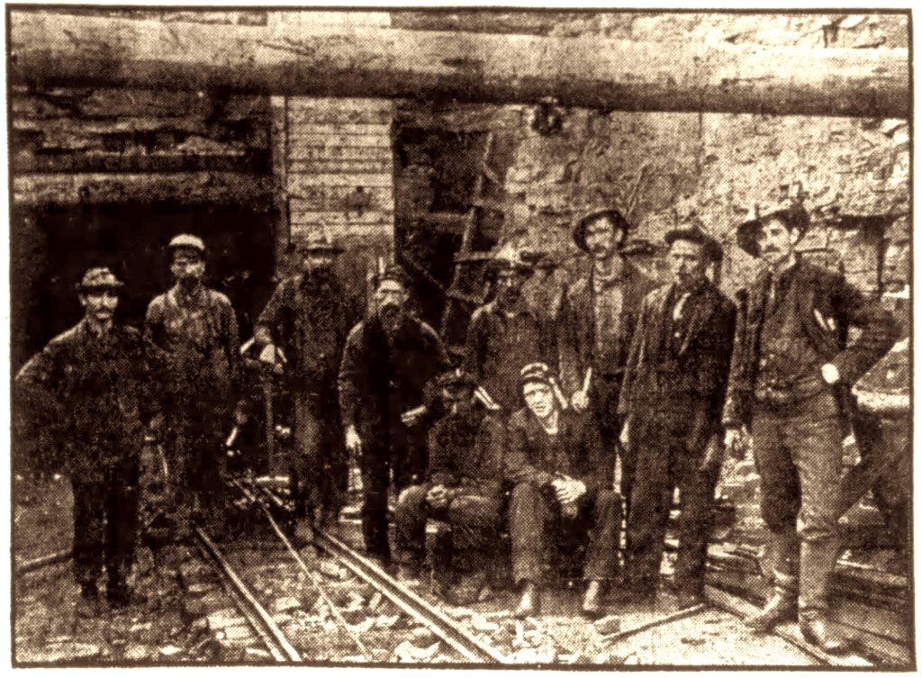
The mouth of the Hell Gate Coal Mine. The Missoula Sentinel, Dec. 15, 1911
While a couple of reports said potentially marketable coal had been found, these went quiet until 1908, when the Hell Gate Coal Company (HGCC) took over operations on the Richli Ranch. By late 1910, the HGCC consisted of a bunk house, tipple (a structure to load coal into carts), and minecarts. The mine employed ten men who mined about 15 tons per day. They used teams of horse-drawn wagons to make daily deliveries at four to five dollars per ton to Missoula, where nearly 300 tons of coal was being used daily.
Joseph Thomas Pardee, a Montana geologist best known for his work on Glacial Lake Missoula, authored probably the most influential paper on Missoula coal in 1913. He estimated that the two-and-a-half sections (1600 acres) of the North Hills that are underlain with a six-foot coal bed had a total tonnage of 17,700,000, or approximately 9,800,000 tons of recoverable coal.
From October 1915 to March 1916, the HGCC mined and sold 1,780 tons of coal for a total of $6,307.92—that’s roughly $188,742 in today’s money. The company also had 8,333 tons of coal ready to be mined. That winter the HGCC’s coal was held in reserve in case of a sudden demand for coal due to severe weather. It seemed like Missoula finally had an established coal mine.
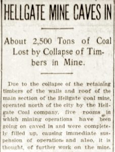
The Missoulian, Jan. 16, 1917
Then it all came crashing down…literally. On the night of Saturday, January 13, 1917, there was a collapse in the main section of the coal mine. None of the 11 miners were working, but five rooms caved in, a loss of about 2,500 tons of coal. The cleanup and re-timbering would cost more than the value of the coal lost in the cave-in, so the HGCC chose to shut down operations.
It wasn’t until nearly 15 years later that Montanans gave the mine one more try. In 1931 a coal mine owner from Roundup, Montana, decided to try his luck at the old Hell Gate Coal mine. Water had filled the tunnel and had to be pumped out, but he wanted to continue the search for commercial coal. The new company made their first advertisement in early 1933 and employed five men by August.
But almost from the beginning, the mine proved to be unlucky. From April 1933 to October 1934, four miners sustained injuries—losing an arm, a fractured hip, a broken back, and a skull fracture and blindness—while working. These accidents, plus dropping coal prices and a world war, marked the beginning of the end for the coal mine. It halted operations in the early 1940s, and by the summer of 1953, the mine was again full of water. At the time it shut down for good, the mine’s main entry was 970 feet long, with tunnels and coal rooms drifting 1,500 feet to the east and 800 feet to the west. All in all, about five acres of coal were removed from this mine in the almost half-century between 1898 and the 1940s.
Today, not much evidence remains of the sometimes-lucky, ultimately not-so-lucky mining activity that reaches back to the earliest days of Missoula. And while Missoula’s coal mining history has basically been erased from the landscape, you can still trace the ancient white volcanic ash layer across the North Hills. The fossils preserved in these beds tell the story of a warmer, wetter, lusher Missoula from almost 40 million years ago, a tantalizing glimpse into the prehistoric past.
The site of the old Hell Gate Coal mine is on private property, but the Moon-Randolph Homestead has a reconstructed early 1900s mining shed as well as the entrance to their “Little Phoebe” coal mine available to the public. Do you have photos or stories of the coal mine? Please contact the author at kallie.moore@mso.umt.edu.
—Kallie Moore is an enthusiastic paleontologist and science communicator. Since 2008, she has been the Collections Manager, or “Fossil Librarian,” of the paleontology collection at the University of Montana. She started as a co-host and content consultant on the YouTube channel PBS Eons with its launch in 2017. Her debut children’s book, Tales of the Prehistoric World, was released in the fall of 2022. And in 2024, Kallie became an executive producer on Why Dinosaurs?, a documentary about dinosaurs and the people who love them.
This article was originally published in the Fall/Winter 2024 issue of Montana Naturalist magazine, and may not be reproduced in part or in whole without the written consent of the Montana Natural History Center. ©2024 The Montana Natural History Center.
Click here to read more articles from Montana Naturalist magazine.
Want to learn more about our programs? Sign up for our e-newsletter! You can also become a member and get discounts on our programs as well as free reciprocal admission to 300+ science centers in North America!