Glacial Lake Missoula: The Short Story
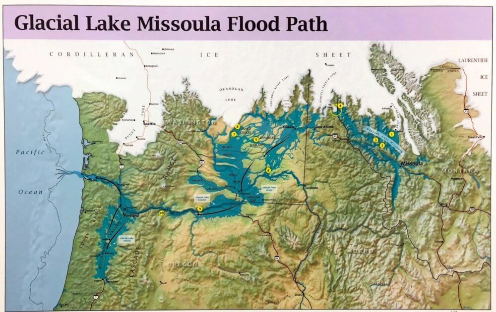
About 15,000 years ago the valleys of western Montana lay beneath a lake nearly 2,000 feet deep. Glacial Lake Missoula formed as the Cordilleran Ice Sheet dammed the Clark Fork River just as it entered Idaho. The rising water behind the glacial dam weakened it until water burst through in a catastrophic flood that raced across Idaho, Oregon, and Washington toward the Pacific Ocean. Thundering waves and chunks of ice tore away soils and mountainsides, deposited giant ripple marks, created the scablands of eastern Washington, and carved the Columbia River Gorge. Over the course of centuries, Glacial Lake Missoula filled and emptied in repeated cycles, leaving its story embedded in the land.
Flood Facts:
- The ice dam was over 2000 feet tall.
- Glacial Lake Missoula was as big as Lakes Erie and Ontario combined.
- The flood waters ran with a force equal to 60 Amazon Rivers.
- Car-sized boulders embedded in ice floated some 500 miles; they can still be seen today!
Visit the Montana Natural History Center to learn more about Joseph Pardee, the geologist who deciphered Glacial Lake Missoula’s clues on the landscape; see the path of the floods; pick up a map of a driving route that visits several Glacial Lake Missoula landmarks; and watch our video on the Great Floods.
You can learn more or prepare for your visit by visiting glaciallakemissoula.org.
Echoes on the Land
Enjoy Echoes on the Land: The Story of Glacial Lake Missoula, created by the Glacial Lake Missoula Chapter of the Ice Age Floods Institute. This series of videos on Glacial Lake Missoula includes information about strandlines, the ripple marks, glacial erratics, and more. View them at MNHC or check them out on YouTube!